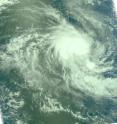
NASA's Aqua Satellite sees a tight Tropical Storm 21S
The Southern Indian Ocean is still warm enough to enable tropical cyclones to form, and Tropical Cyclone 21S did just that today. NASA's Aqua satellite captured infrared and visible images of 21S and the infrared showed some limited areas of strong convection, while the visible image showed a very small, compact storm. At 900 UTC (5 a.m. EDT) today, March 23, Tropical Cyclone 21S was located about 505 miles west of Cocos Island near 12.9 degrees South latitude and 88.3 degrees East longitude.
Tropical Storm 21S has maximum sustained winds near 46 mph (40 knots) and tropical storm-force winds extend out to about 45 miles from the center. Today's NASA Aqua satellite visible image confirmed that 21S is a compact storm, about 90 miles in diameter.
The tropical storm was moving southwest at 8 mph (7 knots). The storm is not expected to reach cyclone strength, although it will likely strengthen a little more before encountering adverse atmospheric conditions. Tropical Storm 21S is expected to be short-lived as vertical wind shear is expected to weaken it over the next couple of days. 21S poses no threat to any land areas.
Source: NASA/Goddard Space Flight Center
Articles on the same topic
- Winds blow off Omais' thunderstorm topsFri, 26 Mar 2010, 21:22:58 UTC
- Imani on the weakening on weekendFri, 26 Mar 2010, 21:22:57 UTC
- Imani reaches cyclone status 'by the tail'Thu, 25 Mar 2010, 17:19:52 UTC
- Tropical storm Omais weakens and doubles in sizeThu, 25 Mar 2010, 17:19:50 UTC
- 02W renamed Tropical Storm Omais, staying at seaWed, 24 Mar 2010, 20:37:29 UTC
- Tropical Storm Imani making a question mark in the Southern Indian OceanWed, 24 Mar 2010, 20:37:28 UTC
- Tropical Depression 02W forms in northwestern PacificMon, 22 Mar 2010, 22:11:08 UTC
Other sources
- Imani on the weakening on weekendfrom Science BlogSun, 28 Mar 2010, 3:14:13 UTC
- Winds blow off Omais' thunderstorm topsfrom Science BlogSun, 28 Mar 2010, 3:14:09 UTC
- Imani on the weakening on weekendfrom PhysorgFri, 26 Mar 2010, 23:07:16 UTC
- Winds blow off Omais' thunderstorm topsfrom PhysorgFri, 26 Mar 2010, 23:07:11 UTC
- Imani on the weakening on weekendfrom Science BlogFri, 26 Mar 2010, 22:21:31 UTC
- Winds blow off Omais' thunderstorm topsfrom Science BlogFri, 26 Mar 2010, 22:21:29 UTC
- Tropical storm Omais weakens and doubles in sizefrom Science BlogThu, 25 Mar 2010, 17:50:38 UTC
- Imani reaches cyclone status 'by the tail'from Science BlogThu, 25 Mar 2010, 17:50:30 UTC
- Imani reaches cyclone status 'by the tail'from PhysorgThu, 25 Mar 2010, 17:50:02 UTC
- Tropical storm Omais weakens and doubles in sizefrom PhysorgThu, 25 Mar 2010, 17:22:38 UTC
- 02W renamed Tropical Storm Omais, staying at seafrom PhysorgWed, 24 Mar 2010, 21:14:08 UTC
- Tropical Storm Imani making a question mark in the Southern Indian Oceanfrom PhysorgWed, 24 Mar 2010, 20:49:17 UTC
- Tropical Storm Imani making a question mark in the Southern Indian Oceanfrom Science BlogWed, 24 Mar 2010, 20:28:39 UTC
- 02W renamed Tropical Storm Omais, staying at seafrom Science BlogWed, 24 Mar 2010, 20:28:37 UTC
- NASA's Aqua Satellite sees a tight Tropical Storm 21Sfrom Science BlogTue, 23 Mar 2010, 20:07:16 UTC
- NASA's Aqua Satellite sees a tight Tropical Storm 21Sfrom PhysorgTue, 23 Mar 2010, 19:14:24 UTC
- Tropical Depression 02W forms in northwestern Pacificfrom Science BlogTue, 23 Mar 2010, 4:28:26 UTC
- Tropical Depression 02W forms in northwestern Pacificfrom PhysorgMon, 22 Mar 2010, 22:21:06 UTC
- Tropical Depression 02W forms in northwestern Pacificfrom Science BlogMon, 22 Mar 2010, 22:07:17 UTC
