NASA satellite sees rainfall in ebbing Edzani
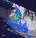
NASA's Tropical Rainfall Measuring Mission satellite captured a clear picture of what's happening within Tropical Storm Edzani, including where the rainfall is happening and where the center of the storm has been breached. Edzani is fading and will continue to fade over the next couple of days. Also known as TRMM, the Tropical Rainfall Measuring Mission satellite is managed by NASA and the Japanese Space Agency, JAXA and the satellite acts like a rain gauge in space by measuring rainfall of storms on Earth from its orbit.
The TRMM satellite passed over Edzani on January 11 at 12:27 a.m. ET (0527 UTC), and noticed that the storm's highest thunderstorm cloud tops had dropped to about 6 miles (10 kilometers), indicating that convection (rapidly rising air that forms thunderstorms) is waning. Stronger convection creates higher, more powerful thunderstorms, but Edzani's is weakening.
The TRMM rainfall analysis revealed that the eastern side of the storm still had areas of heavy rainfall, falling at about 2 inches per hour. However, most of the rainfall was to the east of the center of circulation, and was between .7 and 1.6 inches per hour. The TRMM analysis also showed that the western side of the storm's circulation is open, and there is no convection happening.
The Joint Typhoon Warning Center, the agency that monitors and forecasts tropical cyclones in the Indian Ocean, issued their final warning on Edzani earlier today, January 12, but noted that they will continue to watch Edzani for possible regeneration. The JTWC confirmed what TRMM satellite imagery showed, "Central convection has completely eroded over the past 12 hours with some weak convection remaining along the southern quadrant within the warm frontal zone."
Animated multispectral satellite imagery showed that a weak front with cold-air stratocumulus clouds are wrapping around the western edge of Edzani. It appears that Edzani is also transitioning into an extra-tropical storm.
At 0000 UTC today (or 7 p.m. ET on January 11), Edzani's last position was approximately 975 nautical miles east-southeast of La Reunion island, near 26.1 degrees South Latitude and 72.5 East Longitude. Edzani had maximum sustained winds near 46 mph (40 knots) and it was moving west-southwest near 6 mph (5 knots). Despite the weakening of the storm and transitioning to an extra-tropical storm, Edzani is also moving back over warmer waters, so forecasters will keep a close eye on it for possible regeneration.
Source: NASA/Goddard Space Flight Center
Articles on the same topic
- NASA satellite sees Tropical Storm Edzani becoming extra-tropicalWed, 13 Jan 2010, 20:25:43 UTC
- Still safely at sea, Edzani now a tropical stormMon, 11 Jan 2010, 18:57:06 UTC
- Super cyclone Edzani staying safely at sea spawning super swellsFri, 8 Jan 2010, 21:16:25 UTC
Other sources
- NASA satellite sees Tropical Storm Edzani becoming extra-tropicalfrom PhysorgWed, 13 Jan 2010, 20:56:27 UTC
- NASA satellite sees rainfall in ebbing Edzanifrom PhysorgTue, 12 Jan 2010, 19:21:25 UTC
- NASA satellite sees rainfall in ebbing Edzanifrom Science BlogTue, 12 Jan 2010, 17:14:36 UTC
- Still safely at sea, Edzani now a tropical stormfrom Science BlogMon, 11 Jan 2010, 19:42:15 UTC
- Still safely at sea, Edzani now a tropical stormfrom PhysorgMon, 11 Jan 2010, 19:14:16 UTC
- Super cyclone Edzani staying safely at sea spawning super swellsfrom Science BlogFri, 8 Jan 2010, 23:28:10 UTC
- Super cyclone Edzani staying safely at sea spawning super swellsfrom PhysorgFri, 8 Jan 2010, 21:35:09 UTC
- Super cyclone Edzani staying safely at sea spawning super swellsfrom Science BlogFri, 8 Jan 2010, 21:14:24 UTC
